High Tatras
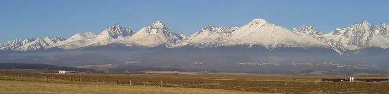
The High Tatras are a mountain range and tourist destination located in Slovakia, spanning the Poprad District, Liptovský Mikuláš District, Kežmarok District, and Lesser Poland Voivodeship. Part of the Eastern Tatras, this 26,000 meter long area reaches an elevation of 2,655 meters across 341 square kilometers. It is one of the most looked-up sights in Slovakia.
Planning a visit
July and August are the warmest months, with daily highs of 11 °C and lows of 2 °C, though July sees about 296 mm of rain. Winter months like January and February feature daily highs of -6 °C and lows of -14 °C. The nearest airport is Poprad-Tatry Airport in Poprad, Slovakia, located 13 km away, while Kraków John Paul II International Airport in Balice, Poland is 104 km away. The capital city of Bratislava is 249 km away.
Visitors can combine a trip to the mountain range with nearby Spiš Castle, which is 49.8 km away.
Weather by month
The warmest month is July, with an average high of 11 °C. The wettest is July, with about 296 mm of rain.
| Jan | Feb | Mar | Apr | May | Jun | Jul | Aug | Sep | Oct | Nov | Dec | |
|---|---|---|---|---|---|---|---|---|---|---|---|---|
| Average high, °C | -6 | -6 | -4 | 1 | 7 | 9 | 11 | 11 | 7 | 4 | -2 | -5 |
| Average low, °C | -13 | -14 | -12 | -8 | -3 | 0 | 3 | 2 | -1 | -4 | -8 | -12 |
| Rainfall, mm | 119 | 111 | 139 | 154 | 238 | 278 | 296 | 247 | 192 | 140 | 150 | 132 |
| Rainy days | 16 | 16 | 14 | 16 | 19 | 17 | 18 | 15 | 13 | 12 | 14 | 15 |
Temperatures and rainfall: 1981–2010 averages for this spot (4 km grid), from CHELSA. Rainy days: 2015–2024, NASA POWER.