Mount Nemrut Nemrut Dağı
Kâhta, Turkey UNESCO World Heritage Site
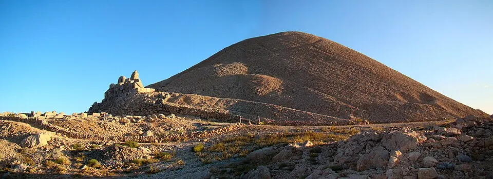
Mount Nemrut is a UNESCO World Heritage Site in the Adıyaman Province of Turkey. This mountain and archaeological site serves as a sanctuary located at an elevation of 2,150 meters.
Planning a visit
The best time to visit is between June and September, when daily highs reach about 23 °C to 28 °C and rainfall is minimal. From July and August, there is only about 1 day of rain per month. In contrast, the winter months are cold, with January seeing daily highs of -2 °C and lows of -10 °C, alongside significant rainfall.
To reach the site, you can fly into Adıyaman Airport, which is 37 km away, or Şanlıurfa GAP Airport, located 61 km from Mount Nemrut. The site is about 555 km from the capital, Ankara. It is one of the most looked-up sights in Turkey, ranking 26th among the country's sights on English Wikipedia.
Weather by month
The warmest month is July, with an average high of 28 °C. The wettest is January, with about 137 mm of rain.
| Jan | Feb | Mar | Apr | May | Jun | Jul | Aug | Sep | Oct | Nov | Dec | |
|---|---|---|---|---|---|---|---|---|---|---|---|---|
| Average high, °C | -2 | -1 | 4 | 10 | 16 | 23 | 28 | 28 | 22 | 15 | 7 | 1 |
| Average low, °C | -10 | -10 | -6 | 0 | 4 | 9 | 14 | 14 | 10 | 4 | -2 | -7 |
| Rainfall, mm | 137 | 123 | 109 | 80 | 56 | 16 | 3 | 2 | 8 | 58 | 99 | 137 |
| Rainy days | 11 | 8 | 12 | 8 | 8 | 3 | 1 | 1 | 1 | 4 | 7 | 9 |
Temperatures and rainfall: 1981–2010 averages for this spot (4 km grid), from CHELSA. Rainy days: 2015–2024, NASA POWER.