Cerrado
Brazil UNESCO World Heritage Site
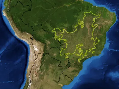
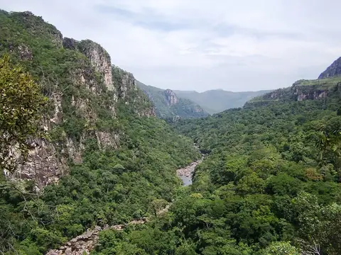
Cerrado in Brazil is a savanna, WWF ecoregion, and natural heritage site designated as a World Heritage Site. Spanning an area of 3,674 square kilometers across Minas Gerais, Mato Grosso, Mato Grosso do Sul, and Goiás, it is one of the most looked-up sights in the country on English Wikipedia.
Planning a visit
The dry season runs from May through August, with June and July experiencing very little rain and daily highs around 27 °C to 28 °C and lows of 16 °C. The wetter months from November through March see heavier rainfall, exceeding 300 millimeters in January, March, and December. Daily highs stay warm throughout the year, reaching up to 31 °C in September.
The site is located 200 kilometers from Brasília. The nearest airport is Presidente Juscelino Kubitschek International Airport in Brasília, situated 209 kilometers away. Nearby sights include Chapada dos Veadeiros National Park, which is 8.8 kilometers away.
Weather by month
The warmest month is September, with an average high of 31 °C. The wettest is December, with about 330 mm of rain.
| Jan | Feb | Mar | Apr | May | Jun | Jul | Aug | Sep | Oct | Nov | Dec | |
|---|---|---|---|---|---|---|---|---|---|---|---|---|
| Average high, °C | 27 | 27 | 27 | 28 | 28 | 27 | 28 | 29 | 31 | 30 | 28 | 27 |
| Average low, °C | 19 | 19 | 19 | 19 | 18 | 16 | 16 | 17 | 20 | 20 | 20 | 20 |
| Rainfall, mm | 302 | 284 | 303 | 144 | 34 | 5 | 2 | 10 | 52 | 171 | 269 | 330 |
| Rainy days | 20 | 20 | 22 | 16 | 3 | 0 | 0 | 1 | 3 | 14 | 23 | 20 |
Temperatures and rainfall: 1981–2010 averages for this spot (4 km grid), from CHELSA. Rainy days: 2015–2024, NASA POWER.