Tsodilo
Botswana UNESCO World Heritage Site
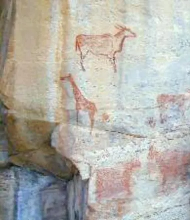
Tsodilo is an archaeological site located in the North-West District of Botswana. As a designated UNESCO World Heritage Site, it covers 48 square kilometers and sits at an elevation of 1,489 meters. It ranks as the fourth most looked-up sight in the country on English Wikipedia.
Planning a visit
The dry season, spanning from May to August, is the most suitable time for a visit. During these months, there is minimal rain and temperatures are cooler, with daily highs ranging between 24 °C and 28 °C and lows dropping as far as 8 °C. Conversely, the period from December to March sees higher rainfall, often exceeding 100 mm per month, which may affect travel. October is the hottest month, with daily highs reaching 34 °C.
Tsodilo is accessible via Shakawe Airport, located 45 kilometers away. For international connections, Maun International Airport is 221 kilometers from the site. The site is situated 782 kilometers from Gaborone, the capital of Botswana. There are no nearby sights listed for combination with a trip to Tsodilo.
Weather by month
The warmest month is October, with an average high of 34 °C. The wettest is January, with about 127 mm of rain.
| Jan | Feb | Mar | Apr | May | Jun | Jul | Aug | Sep | Oct | Nov | Dec | |
|---|---|---|---|---|---|---|---|---|---|---|---|---|
| Average high, °C | 30 | 29 | 30 | 29 | 27 | 25 | 24 | 28 | 32 | 34 | 33 | 31 |
| Average low, °C | 20 | 19 | 19 | 17 | 13 | 9 | 8 | 11 | 15 | 19 | 20 | 20 |
| Rainfall, mm | 127 | 103 | 79 | 18 | 2 | 2 | 0 | 0 | 2 | 11 | 55 | 91 |
| Rainy days | 18 | 14 | 14 | 5 | 0 | 0 | 0 | 0 | 0 | 1 | 6 | 15 |
Temperatures and rainfall: 1981–2010 averages for this spot (4 km grid), from CHELSA. Rainy days: 2015–2024, NASA POWER.