Serra da Capivara National Park Parque Nacional Serra da Capivara
Brazil UNESCO World Heritage Site

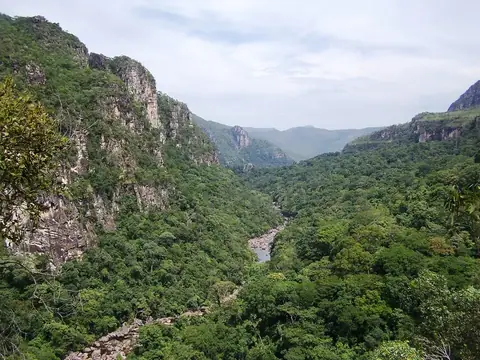
Serra da Capivara National Park is a natural heritage site and a UNESCO World Heritage Site in Brazil. It is one of the 23 sights of the country listed on this site and ranks as the 17th most looked-up sight in Brazil on English Wikipedia.
Planning a visit
The best time to visit depends on weather preferences. July and August are the driest months with no rain and daily highs between 30 °C and 31 °C. September and October are the warmest months, with daily highs reaching 33 °C. The rainy season occurs between December and March, when monthly rainfall reaches up to 140 mm and there are approximately 14 to 15 rainy days per month.
To reach the park, the nearest airport is Senador Nilo Coelho Airport (PNZ) in Petrolina, which is 231 km away. The park is 982 km from the capital, Brasília. The larger Deputado Luiz Eduardo Magalhães International Airport (SSA) in Salvador is 660 km from the area.
Weather by month
The warmest month is October, with an average high of 33 °C. The wettest is March, with about 140 mm of rain.
| Jan | Feb | Mar | Apr | May | Jun | Jul | Aug | Sep | Oct | Nov | Dec | |
|---|---|---|---|---|---|---|---|---|---|---|---|---|
| Average high, °C | 29 | 29 | 29 | 29 | 30 | 30 | 30 | 31 | 33 | 33 | 32 | 31 |
| Average low, °C | 22 | 22 | 21 | 22 | 22 | 21 | 20 | 20 | 22 | 23 | 23 | 22 |
| Rainfall, mm | 129 | 119 | 140 | 74 | 24 | 5 | 2 | 0 | 5 | 29 | 84 | 98 |
| Rainy days | 14 | 15 | 14 | 8 | 2 | 1 | 0 | 0 | 1 | 3 | 10 | 9 |
Temperatures and rainfall: 1981–2010 averages for this spot (4 km grid), from CHELSA. Rainy days: 2015–2024, NASA POWER.