Charlottesville
City in United States

Charlottesville is a city in the United States with a population of 46,553 in 2020. Located 158 km from Washington, D.C., the city draws visitors with its notable UNESCO sights.
What to see
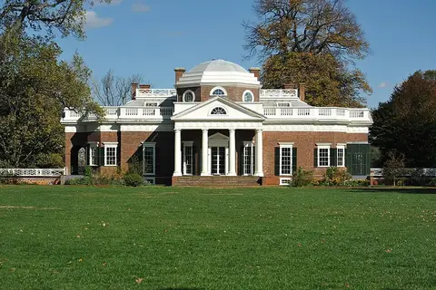
Visitors can explore two prominent UNESCO sites located in the area. These include the historic University of Virginia and the Monticello estate.
When to go
The climate features daily highs and lows throughout the year. January is the coldest month with daily highs of 7 °C and lows of -2 °C, along with 68 mm of rain over about 9 days. July is the warmest month with daily highs reaching 31 °C and lows of 20 °C, accompanied by 119 mm of rain on about 16 days. May through August experience higher rainfall amounts, ranging from 95 mm to 119 mm.
Getting there
The nearest airport is Charlottesville Albemarle Airport, situated 12 km from the city. Richmond International Airport serves as a hub located 117 km away.
Top sights in Charlottesville

Weather by month
The warmest month is July, with an average high of 31 °C. Rain is spread fairly evenly through the year.
| Jan | Feb | Mar | Apr | May | Jun | Jul | Aug | Sep | Oct | Nov | Dec | |
|---|---|---|---|---|---|---|---|---|---|---|---|---|
| Average high, °C | 7 | 9 | 14 | 20 | 24 | 29 | 31 | 30 | 26 | 20 | 14 | 8 |
| Average low, °C | -2 | -1 | 3 | 8 | 13 | 18 | 21 | 20 | 16 | 10 | 5 | 0 |
| Rainfall, mm | 68 | 73 | 94 | 84 | 105 | 95 | 119 | 100 | 109 | 90 | 93 | 85 |
| Rainy days | 9 | 10 | 10 | 10 | 15 | 14 | 16 | 15 | 10 | 7 | 6 | 8 |
Temperatures and rainfall: 1981–2010 averages for Charlottesville (4 km grid), from CHELSA. Rainy days: 2015–2024, NASA POWER.